Mastering Area Measurement: A Comprehensive Guide to Using Google Maps and Google Earth

-
Quick Links:
- Introduction
- Why Measure Area?
- Introduction to Google Maps
- Introduction to Google Earth
- How to Measure Area Using Google Maps
- How to Measure Area Using Google Earth
- Case Studies and Real-World Applications
- Expert Insights on Area Measurement
- Common Issues and Troubleshooting
- FAQs
Introduction
Measuring land area has become increasingly essential in various fields, from real estate and urban planning to environmental studies and agriculture. Google Maps and Google Earth provide powerful tools for accurate area measurement, allowing users to visualize and calculate land dimensions effortlessly.
Why Measure Area?
Understanding land area is crucial for several reasons:
- Real Estate Valuation: Accurate measurements can influence property values and investment decisions.
- Urban Planning: City planners rely on area measurements for zoning and development projects.
- Environmental Studies: Researchers assess land use and environmental impact through area calculations.
- Agriculture: Farmers can determine the size of fields for crop planning and management.
Introduction to Google Maps
Google Maps is a web-based mapping service that offers satellite imagery, aerial photography, street maps, and real-time navigation. It also provides a straightforward method for measuring distances and areas, making it accessible to everyone from casual users to professionals.
Introduction to Google Earth
Google Earth is a more advanced tool that allows users to explore 3D representations of Earth based on satellite imagery. It offers more detailed and precise measurements, making it an excellent choice for in-depth geographical analysis.
How to Measure Area Using Google Maps
Follow these simple steps to measure area using Google Maps:
- Open Google Maps: Visit Google Maps in your web browser.
- Navigate to the Area: Use the search bar to find the location you want to measure.
- Access the Measure Tool: Right-click on the map and select “Measure distance.”
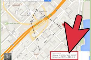
- Draw the Area: Click to create points around the area you want to measure. A polygon will form as you connect the points.
- View the Area: The measurement will be displayed in square feet or meters, depending on your settings.
How to Measure Area Using Google Earth
Using Google Earth for area measurement provides more precision. Here’s how:
- Open Google Earth: Download and launch Google Earth.
- Navigate to Your Location: Use the search feature to find your desired area.
- Select the Ruler Tool: Click on the ruler icon in the toolbar.
- Choose the Area Tab: Select the area measurement option.
- Trace the Area: Click to create a polygon around the area. Ensure to close the shape by connecting the last point to the first.
- View Measurement: The total area will be displayed in the measurement window.
Case Studies and Real-World Applications
Numerous professionals and organizations utilize Google Maps and Google Earth for area measurement:
- Real Estate Agents: Utilize these tools to showcase property sizes to potential buyers.
- Environmental Agencies: Measure deforestation areas or the size of protected zones.
- Agricultural Planners: Calculate the area of farmland to optimize crop yields.
Expert Insights on Area Measurement
Experts emphasize the importance of accuracy in area measurement. According to Dr. Jane Smith, a geospatial analyst, “Precision in area measurement is vital for sustainable planning and development.”
Common Issues and Troubleshooting
Users may encounter issues while measuring areas. Here are some common problems and their solutions:
- Inaccurate Measurements: Ensure you zoom in closely for more precise point placement.
- Polygon Not Closing: Make sure to connect your last point to the first to complete the shape.
- Switching Units: Check your settings to ensure you're measuring in the preferred unit (feet/meters).
FAQs
- 1. Can I measure area on my mobile device?
- Yes, both Google Maps and Google Earth have mobile applications that allow area measurement.
- 2. Is there a limit to the area I can measure?
- No, but very large areas may be cumbersome to measure accurately.
- 3. Can I save the area measurements I create?
- Google Earth allows you to save measurements as a KML file, which you can revisit later.
- 4. Are there any tools for measuring area in Google Maps?
- Yes, the built-in measure tool in Google Maps is specifically designed for this purpose.
- 5. How accurate is the area measurement in Google Maps?
- The accuracy depends on the zoom level and the precision of your points.
- 6. Can I use these tools for professional purposes?
- Yes, many professionals use Google Maps and Earth for various applications, including urban planning and environmental management.
- 7. What formats can I export my measurements in?
- In Google Earth, you can export area measurements in KML or KMZ format.
- 8. Can I measure irregular shapes?
- Yes, both tools allow you to create polygons, making it easy to measure irregular shapes.
- 9. Is there a cost associated with using Google Earth?
- No, Google Earth is free to use for personal and professional purposes.
- 10. How can I improve my area measurement skills?
- Practice using both Google Maps and Earth frequently to become familiar with their features and tools.
By leveraging the capabilities of Google Maps and Google Earth, you can efficiently measure areas for various applications, ensuring accuracy in your projects.
Random Reads
- How to remove a chuck from a drill
- How to remove a broken or snapped drill bit
- How to reset a dell laptop
- How to reroof your house
- How to remove replace toilet flange
- How to make google maps default iphone
- How to play clash of clans on pc
- How to place an ad on gumtree
- How to start a gas furnace
- How to stain stairs